
J K Vaid
I am sure you all must have visited the popular picnic spots of Jammu – Mansar Lake and the nearby Surinsar Lake. However, you may not be that much conscious of many a unique feature pertaining to the twin lakes, as have been revealed in the recent scientific studies carried out by Geological Survey Of India (GSI). In the first ever systematic Geoenvironmental Survey in 1996-97 by a team of three Geologists, two Surveyors and two Chemists of GSI under my guidance and supervision, a wealth of base-line data has been generated and many myths regarding depth of the lakes, apprehensions about their shrinkage or siltation and pollution or environmental degradation etc. have been exploded.
It is high time that this published scientific data be given wide publicity by the concerned quarters such as Mansar & Surinsar Lakes Development Authority, Departments of Tourism and Information etc. through revised/updated brochures. The abstract version of this data is published in Records Of Geological Survey Of India, Vol.131 Part-8: Extended Abstracts Of Progress Reports Of Northern Region : Field Season 1996-97, P.16 – 24. Full report on Geoenvironmental Appraisal Of Mansar & Surinsar Lakes, issued in 2001, is also available with Geological Survey Of India.
Religious Beliefs & Myths :
Mansar lake is considered to be abode of a Hindu serpent god, Sheshnag by the locals and populace of surrounding areas and some religious rites such as mundan ceremonies are performed here for their sons by many families at the ancient Sheshnag temple, located at northeastern margin of the lake. Even to this day, locals and many others believe that the lake doesn’t have any bottom. In other words they mean that the depth of the lake is so great that it cannot be fathomed. Well, when oceans can be fathomed, why not a small lake? Science has made all that possible.
Origin of the Lakes
Regarding the formation or origin of the lakes also, there are mythological stories such as – the great Arjuna of Mahabharata times shot an arrow to carve out twin lakes of Mansar and Surinsar. But such magical things are very hard to digest, especially by the modern educated generation. These lakes have been formed by a well defined rare geological process during mountain building diastropic processes. In short they are net result of God given boon.
Have you ever noticed that for reaching Mansar lake, you have to ascend though a hill slope from southern Samba side? From northern Battal side (on Dhar – Udhampur road) also there is a gentle upward gradient towards the lake. Isn’t this peculiar? Normally, the lakes are found in depressions and you have to go down to access them. Generally, only glacial lakes such as Kaplas Kund also called as Vaskund at 13500 feet height in the Kaplas Range in Bhadarwah area, are formed at great heights due to scooping action of moving ice (glaciers) on the rocks over very prolonged period of times.
So, Mansar lake is formed on a Structural High called as an Anticline in geological parlance. Anticline means an arch of rocks with its high turned upwards. Same is true for its sister lake called as Surinsar, situated at 11.7 Km Northwest (N55W) of Mansar lake. The core of this anticline has a number of fractures or faults, including cross-faults. It is these fractures or faults which have resulted in spring activity in the lake basins (Mansar and Surinsar) yielding perennial source of lake waters. Most of the lake waters are coming from below, welling up as copious springs along the fracture planes, in artesian conditions..
Next time you visit Mansar or Surinsar, please note that no stream or nala is feeding the lakes for water source and the catchment area of both the lakes is also very limited i.e. less than one sq km, the annual rainfall of the area being about 1400 mm. In other words both the lakes are closed drainage type.
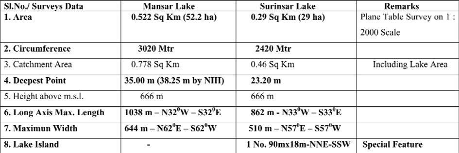
Facts & Figures:
So let us have the facts about the twin lakes, as revealed by authentic ground surveys (Plane Table Survey with Alidate on 1:2000 scale, Use of Klyen Sub-Surface Sampler for bathymetry and water sample collection at depths of lake water column and allied technical studies. The first time base line data on Mansar and Surinsar lakes is tabulated below:-
National Institute of Hydrology (NIH) has also been undertaking Water Quality Surveys of the Mansar and Surinsar Lake Waters collected from surface, periodically. Their findings of Total Dissolved Solids (TDS) in the lake waters conform with analytical reports of GSI carried out more than two decades ago.
Conclusion:
So we are lucky to have such beauties in the form of two very deep fresh water lakes in Jammu which still enjoy pristine glory of environment. Any future surveys of this nature would reveal the updated status of the lakes at that time. This is the first ever baseline data generated which will be useful in the future studies for comparative assessment. Of course, the modern surveying techniques using Digital Total Station Surveys would yield high precision data for area calculations and the same is recommended. It does not involve much cost factor also. Technical experts need also to be taken on board in course of development activities at and around the lakes. In the year 1977, Surinsar lake was surveyed by Department of Geology & Mining, J&K Government by Plane Table mapping on 1 : 2000 scale. That report was also consulted in the studies by GSI. On comparison of 2 maps on same scale of 1:2000, one prepared by DGM in 1977 and the other by GSI in 1996 , it was found that there is no change in depth or area of Surinsar lake in 19 years time. No early data on accurate surveys existed for Mansar lake.
This, however, doesn’t mean that we should not take due care about the ecology and pollution of the lakes. We must preserve them in all purity and beauty. Mansar and Surinsar lakes are amongst the deepest fresh water lakes in India. We have much deeper lakes in Ladakh, but they are not fresh water, they are brackish waters, remnants of great seas of the past with enchanting geological history. Kashmir lakes which also are fresh water lakes are of much lesser depths, Mansbal being the deepest one amongst them at around 10 metres depth. Nainital lake at the noted hill station Nainital in Uttrakhand is considered to be very deep. It, however, is 18 metres only at its deepest point.
The lakes can be approached from N.H. 44 off Samba and from Jammu, as well as Udhampur, at short distance of 23 km, 60 km and 45 km respectively.
(The author is a noted Geologist & Retd. Director Geological Survey of India)